Hi Readers: Now that we are in the winter weather of the year, we must all face the fact that, for flying, icing conditions on the ground or in the air is upon us (although icing conditions can occur in flight at any time of the year depending on the weather systems). Icing conditions on the ground before flight without de-icing is dangerous (and foolhardy) and icing conditions at altitude without de-icing and anti-icing are dangerous and lethal. In flight, icing can cause rapid loss of altitude and/or loss of control in minutes. If your airplane is not equipped with de-icing and anti-icing gear, or not certified for flight in icing conditions, its your knowledge and good judgment of the weather against nature.
Although I won't dwell on the many aircraft accidents over the years caused by icing, some of the worst fatal accidents have been caused by icing - principally due to our lack of knowledge, our judgment, and lack of anti-icing equipment. General Aviation (GA) and Commuter type (Part 23) airplanes are the most vulnerable since they are flown at the lower altitudes where icing conditions occur, and most of the airplanes are not equipped with ice-prevention gear or the intention of flight was not to encounter weather conditions.
How, then, does inflight icing occur? Well, we have to be flying in, around, or through stratus and cumulonimbus clouds containing water droplets at or nearing freezing temperatures, and nature takes care of the rest. There can be induction icing - ice forming around the engine air intake (particularly bad for jet engines since ice will form in chunks which may be ingested) or structural icing, either as clear or rime ice, formed when supercooled water droplets impact the wing and control surfaces (top and bottom) freezing in a solid sheet of ice or in a irregular shape - usually between zero degrees and minus 10 degrees centigrade. Such icing has been encountered in a cumulonimbus cloud at temperatures down to minus 25 degrees centigrade. Mixed icing, clear and rime ice, which result in an irregular shape on airfoils, can occur while flying through snow, ice pellets, or small hail.
The effects of ice on the airplane are cumulative - thrust is reduced, drag increases, lift lessens, and weight increases. The combined results are an increase in stall speed and a deterioration of airplane performance. In extreme cases, 2" to 3" of ice can form on the leading edge of an airfoil in less than 5 minutes.
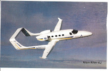
A recent Cessna 208 Caravan accident near Mt. Ranier, Washington, reminds us that icing problems are still with us, in spite of de-icing and anti-icing equipment, along with GPS and digital instruments. The NTSB and Cessna Aircraft are still investigating.
In Airline and Part 121 flying (all IFR flight plans), cancellations and delays due to icing conditions can cost millions of dollars in one day. The cost of de-icing fluid, at a cost of 3 to 4 dollars/gallon adds to their problems. Part 121 operations covers the transport aircraft icing conditions. Part 135 and 91 flying is covered under 135.227 and 91.527.
NASA, FAA, and NTSB have been conducting research on aircraft icing problems over the years (see applicable icing FAA Advisory Circulars) and as of 6-1-07 the FAA was still working on a proposed rulemaking (Docket #FAA-2007-27654), titled Activation of Ice Protection, applying, principally, to Part 25 Transport Category airplanes. (It is hoped that FAA will follow with Part 23 aircraft). Under the proposal, Aircraft Manufacturers would be required to add an ice-detection and activation system to the present de-ice and anti-ice systems, and mandate that the protection system operate automatically and continuously. I think there is going to be a lot of discussion on this proposal.
How to avoid flying in icing conditions? For GA and Commuter aircraft, use all available weather services and reports to pinpoint icing areas and then plan on avoiding them. If you encounter icing conditions at altitude, use your available de-icing and anti-icing equipment immediately, change altitude up or down, and/or make a change in course (not necessarily 180 degrees since the true direction of the weather system is not known). Leave the autopilot off. Replan your flight or land at the nearest available airport (that will accommodate your airplane) and wait it out.
Proper preflight action includes, on filing an IFR flight plan, determining the freezing level and the levels above and below for weather precipitation areas. If your flight route penetrates the freezing level, request a new altitude or route. Make use of appropriate SIGMETS, AIRMETS, and PIREPS, and any other source of inflight weather advisory in planning and executing en route flight. In general, make a habit of checking FAA Advisory Circulars - FAAs method of advising new developments or action on pertinent problems.
Thanks for listening and Happy Thanksgiving! R.S.
Showing posts with label clouds. Show all posts
Showing posts with label clouds. Show all posts
Tuesday, November 20, 2007
Saturday, August 18, 2007
The Relative Humidity - Dewpoint Relationship
Before we get started today - Did you know that our global warming of today is only 6 degrees C. higher than that of the Ice Age? But that increase in temperature may cause heat waves, intense precipitation, droughts, and tropical storms. The sea level will be rising, too, due to thermal expansion of the oceans and the melting of glaciers.
Okay - Relative humidity (RH) is the actual amount of moisture in the air, compared to the total amount of moisture the air could hold at the current temperature. Relative - yes. If the RH is 70%, the air is holding 70% of the total amount of moisture that it can at the current temperature and pressure. Normally we think about RH in terms of how it affects our body temperature - if the humidity is high we feel the heat or if the humidity is low we feel much better. In aviation we are more concerned with the Dewpoint (DP)/temperature relationship and how it affect the air in which we fly.
The relationship actually defines the concept of RH. Given in degrees, the DP is the temperature at which the air can hold no more moisture. Perhaps, in simpler terms, the air is saturated with moisture. When that temperature is reached the moisture begins to condense in the form of fog, dew, frost, clouds, rain, hail or snow. The relative gap has now closed and the RH is 100%. Since the amount of moisture the air can hold is driven by the temperature, we find that as the temperature increases the air can hold a greater amount of water.
If a cubic meter of air has 17 grams of water vapor at saturation, at a temperature of 68 degrees Fahrenheit (F.), the RH would be 100%. Any further cooling would result in condensation of the vapor. If we lower the temperature to, say, 49 degrees F., the air can only hold 9 grams of water vapor, which would be saturation, but the RH would still be 100%. If we raise that temperature to 86 degrees F., the 17 grams of water vapor will be 56% of the 30 grams of water that can be held, so the RH is 56%.
The spread between the current temperature and the DP can be useful in determining, say, a cloud base. If your current temperature was 85 Degrees F. and the forecasted DP was 71 degrees F., taking the spread of 14 degrees F. and dividing by a convergence (saturation) rate of 4.4 degrees F. and dividing by 1,000, you will have determined an approximate cloud base of 3,180 ft above ground level.
How does the air reach its saturation point? When warm air moves over a cold surface, the temperature of the air drops and reaches the saturation point. The saturation point may also be reached when cold air and warm air mix, or when at night the air cools on contact with the ground. Obviously, at lower temperatures the DP spread or saturation point is less because the amount of water vapor the air can hold is less at that temperature.
A remaining point to think about, then, with respect to flight, is that DP takes on an added importance at lower temperatures since the spread is less and what that spread indicates - freezing, icing, snow, etc. These indications will be even more important at altitude.
In order for clouds to form there must be adequate water vapor and condensation nuclei, as well as a method of cooling. When the air then cools and reaches its saturation point, the invisible water vapor changes to a visible state by latching on to the miniscule particles of matter or nuclei.
Usually, the temperature - DP relationship is given in weather broadcasts and other reporting systems rather than RH, since the relationship is more meaningful and a better indicator of weather aspects. The temperatures are almost always reported in degrees Celcius.
The various types of weather reports and reporting systems will taken up in future blogs.
Thanks for listening. RS.
Friday, June 22, 2007
Aviation Weather - Clouds
The study of weather, perhaps on a par with air traffic control, is as necessary to the pilot as his airplane. Moreover, the state of the weather will determine whether the pilot can conduct his flight, and whether the flight will be made under VFR (Visual Flight Rules) or IFR (Instrument Flight Rules) conditions. The study of weather, so necessary to successful and safe flight, involves many elements and conditions (wind, air masses, pressure areas, fronts, wind shear, thunderstorms, wake turbulence, etc.) which cannot be absorbed all at once.
So let's begin with what the sky shows us - Clouds:
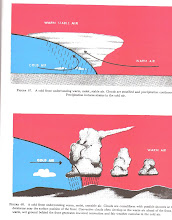
Of themselves, clouds are indications to the pilot of air motion, air stability, moisture, altitude of precipitation, the freezing level, the type air mass, position of fronts, and the warm or cold sector (which are also important indicators), and sometimes help identify weather hazards. And we must remember that the clouds and what they indicate are in a state of change, hour by hour.
We can classify clouds as upper, middle, or lower, and identify those clouds by name; both modified by a prefix or suffix. As weather has its own language, so do the clouds. Let's begin with the uppermost cloud form, that of Cirrus, since it will be the first group of clouds seen as weather approaches; and followed by Alto or middle clouds, and stratus types for lower clouds. The following are classified and identified:
So let's begin with what the sky shows us - Clouds:
Of themselves, clouds are indications to the pilot of air motion, air stability, moisture, altitude of precipitation, the freezing level, the type air mass, position of fronts, and the warm or cold sector (which are also important indicators), and sometimes help identify weather hazards. And we must remember that the clouds and what they indicate are in a state of change, hour by hour.
We can classify clouds as upper, middle, or lower, and identify those clouds by name; both modified by a prefix or suffix. As weather has its own language, so do the clouds. Let's begin with the uppermost cloud form, that of Cirrus, since it will be the first group of clouds seen as weather approaches; and followed by Alto or middle clouds, and stratus types for lower clouds. The following are classified and identified:
- Upper clouds: Cirrus, cirrocumulus, cirrostratus, and cirrus nothus ( a scarf cloud at the top of a built-up cumulus - at high altitude). The bases run from 18,000 to 45,000 feet.
- Middle clouds: Altocumulus, altostratus, altocumulus lenticularus - actually the source of heavy or hard rain or snow is altostratus. The bases run from 6,500 to 23,000 feet.
- Lower clouds are stratus, cumulus, stratocumulus, and nimbostratus - seen as rain coming from stratus. Cumulonimbus is a builtup cloud from 1,000 feet 10,000 feet or more, with bases from 300 feet to 6,500 feet.
As indicated, clouds can be built up vertically or can be fractured on a horizontal level. Scud is a spurt of moving cumulus or stratus on a horizontal level. Clouds formed by vertical currents, such as cumulonimbus, obviously are formed by unstable air; whereas clouds, such as stratus, are formed by cooling of a stable layer of air. Altocumulus castellanus clouds are convective clouds of rough turbulence and some icing.
High clouds are composed of ice crystals or supercooled water droplets. Middle clouds are primarily suspended water, or supercooled droplets. Low clouds - fog or precipitation - rain, sleet, snow, and turbulence will occur in some areas depending on the time of year and the temperature.
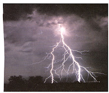
A strong buildup of cumulus may indicate a thunderstorm, with accompanied thunder and lightning. Tornadoes can form from the bases of a long line of cumulus and stratus, indicating very unstable air.
Clouds are also indicative of the type of air mass present (artic, polar, tropical, etc.) and fronts, either cold or warm. A front is a meeting of two dissimilar air masses. Air Masses and Fronts will be discussed in detail in the near future. RS.
Sunday, June 3, 2007
Ceiling and Visibility
Ceiling and visibility are two basic weather elements which must be considered in all flying beginning with your flight planning. Normally we don't give the two elements much thought. We look at the sky - it's either cllear or cloudy. And we look out and around to see how far we can see objects. But for flying, the broad perspective must be narrowed to specific judgments.
The FAA's definition of ceiling is "the height above the earth's surface of the lowest layer of clouds or obscuring phenomena that is reported as broken, overcast, obscuration, and not classified as thin or partial". Pretty wordy and a little confusing, yes?
Well, let's get practical - if you cannot see clouds in the sky or you have something like fog or haze, you have either no ceiling at all or you have ceiling zero, depending on whether the condition is thin or heavy in obscuration.
Weather Observers classify clouds 3/10 or less as scattered, 6/10 as cloudy or a ceiling, 10/10 as overcast. And, of course, heavy fog would be obscuration or ceiling zero.
Now visibility is another matter. We usually think of seeing objects in terms of miles (statute), say 1/4 mile, 1/2 mile, 1/ mile, 3 miles, etc., a matter of distance judgment - relating much to visual acuity used in connection with takeoff, landing, and clearances, and VFR and IFR flight. In fact, ceiling and visibility appears as the first pair of elements used in our flight planning.
As stated (all too simply) in the FARs (Federal Air Regulations), IFR flight is weather conditions below the minimums for flight under VFR conditions.
In any case, to the pilot ceiling means dealing with clouds, sky cover, at what altitudes, and their movement over time. Visibility relates to all kinds of weather conditions - rain, snow, fog, smoke, and haze in connection with all phases of flight and appears perhaps as the first defining factor in planning whether you fly VFR or IFR.
Subscribe to:
Posts (Atom)