So let's begin with what the sky shows us - Clouds:
Of themselves, clouds are indications to the pilot of air motion, air stability, moisture, altitude of precipitation, the freezing level, the type air mass, position of fronts, and the warm or cold sector (which are also important indicators), and sometimes help identify weather hazards. And we must remember that the clouds and what they indicate are in a state of change, hour by hour.
We can classify clouds as upper, middle, or lower, and identify those clouds by name; both modified by a prefix or suffix. As weather has its own language, so do the clouds. Let's begin with the uppermost cloud form, that of Cirrus, since it will be the first group of clouds seen as weather approaches; and followed by Alto or middle clouds, and stratus types for lower clouds. The following are classified and identified:
- Upper clouds: Cirrus, cirrocumulus, cirrostratus, and cirrus nothus ( a scarf cloud at the top of a built-up cumulus - at high altitude). The bases run from 18,000 to 45,000 feet.
- Middle clouds: Altocumulus, altostratus, altocumulus lenticularus - actually the source of heavy or hard rain or snow is altostratus. The bases run from 6,500 to 23,000 feet.
- Lower clouds are stratus, cumulus, stratocumulus, and nimbostratus - seen as rain coming from stratus. Cumulonimbus is a builtup cloud from 1,000 feet 10,000 feet or more, with bases from 300 feet to 6,500 feet.
As indicated, clouds can be built up vertically or can be fractured on a horizontal level. Scud is a spurt of moving cumulus or stratus on a horizontal level. Clouds formed by vertical currents, such as cumulonimbus, obviously are formed by unstable air; whereas clouds, such as stratus, are formed by cooling of a stable layer of air. Altocumulus castellanus clouds are convective clouds of rough turbulence and some icing.
High clouds are composed of ice crystals or supercooled water droplets. Middle clouds are primarily suspended water, or supercooled droplets. Low clouds - fog or precipitation - rain, sleet, snow, and turbulence will occur in some areas depending on the time of year and the temperature.
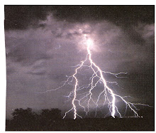
A strong buildup of cumulus may indicate a thunderstorm, with accompanied thunder and lightning. Tornadoes can form from the bases of a long line of cumulus and stratus, indicating very unstable air.
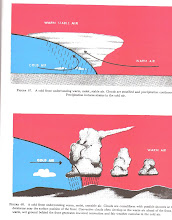
Clouds are also indicative of the type of air mass present (artic, polar, tropical, etc.) and fronts, either cold or warm. A front is a meeting of two dissimilar air masses. Air Masses and Fronts will be discussed in detail in the near future. RS.


No comments:
Post a Comment