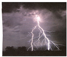
Before we get started today - Did you know that our global warming of today is only 6 degrees C. higher than that of the Ice Age? But that increase in temperature may cause heat waves, intense precipitation, droughts, and tropical storms. The sea level will be rising, too, due to thermal expansion of the oceans and the melting of glaciers.
Okay - Relative humidity (RH) is the actual amount of moisture in the air, compared to the total amount of moisture the air could hold at the current temperature. Relative - yes. If the RH is 70%, the air is holding 70% of the total amount of moisture that it can at the current temperature and pressure. Normally we think about RH in terms of how it affects our body temperature - if the humidity is high we feel the heat or if the humidity is low we feel much better. In aviation we are more concerned with the Dewpoint (DP)/temperature relationship and how it affect the air in which we fly.
The relationship actually defines the concept of RH. Given in degrees, the DP is the temperature at which the air can hold no more moisture. Perhaps, in simpler terms, the air is saturated with moisture. When that temperature is reached the moisture begins to condense in the form of fog, dew, frost, clouds, rain, hail or snow. The relative gap has now closed and the RH is 100%. Since the amount of moisture the air can hold is driven by the temperature, we find that as the temperature increases the air can hold a greater amount of water.
If a cubic meter of air has 17 grams of water vapor at saturation, at a temperature of 68 degrees Fahrenheit (F.), the RH would be 100%. Any further cooling would result in condensation of the vapor. If we lower the temperature to, say, 49 degrees F., the air can only hold 9 grams of water vapor, which would be saturation, but the RH would still be 100%. If we raise that temperature to 86 degrees F., the 17 grams of water vapor will be 56% of the 30 grams of water that can be held, so the RH is 56%.
The spread between the current temperature and the DP can be useful in determining, say, a cloud base. If your current temperature was 85 Degrees F. and the forecasted DP was 71 degrees F., taking the spread of 14 degrees F. and dividing by a convergence (saturation) rate of 4.4 degrees F. and dividing by 1,000, you will have determined an approximate cloud base of 3,180 ft above ground level.
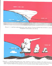
How does the air reach its saturation point? When warm air moves over a cold surface, the temperature of the air drops and reaches the saturation point. The saturation point may also be reached when cold air and warm air mix, or when at night the air cools on contact with the ground. Obviously, at lower temperatures the DP spread or saturation point is less because the amount of water vapor the air can hold is less at that temperature.
A remaining point to think about, then, with respect to flight, is that DP takes on an added importance at lower temperatures since the spread is less and what that spread indicates - freezing, icing, snow, etc. These indications will be even more important at altitude.
In order for clouds to form there must be adequate water vapor and condensation nuclei, as well as a method of cooling. When the air then cools and reaches its saturation point, the invisible water vapor changes to a visible state by latching on to the miniscule particles of matter or nuclei.
Usually, the temperature - DP relationship is given in weather broadcasts and other reporting systems rather than RH, since the relationship is more meaningful and a better indicator of weather aspects. The temperatures are almost always reported in degrees Celcius.
The various types of weather reports and reporting systems will taken up in future blogs.
Thanks for listening. RS.
Subscribe to:
Post Comments (Atom)


No comments:
Post a Comment