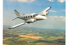
Hi Readers: It's time that I explained the unmarked photo on my site as I previously promised. The photo - A twin-engined Aero Commander 560 in a 90 degree nosedown attitude just short of contacting the ground. Here is the story - I investigated this accident for the NTSB on 3-19-71. We'll skip the names.
The pilot rented the twin-engine Aero Commander 560 from World West Aviation in Van Nuys, CA. the morning of the accident to transport himself and four other engineers from two different companies to Helendale, Ca. Auxiliary airport to conduct a drop test (6 runs) of an electronic parachute dsevice. The landing was made at Helendale (North of Victorville, Ca.), and it was reported that the airplane was functioning normally after the en route flight. The test plan called for a number of runs at altitude, releasing the electronic parachute device out the door from the left rear seat. The wind was determined to be from the north at about 15-20 mph. The first run was made from about 2,000' into the wind and was successful. Since the device landed approximately 1/4 mile south of the Auxilliary field, the second run was planned for 1,000'. Prior to the takeoff, the pilot mentioned the possibility of "cutting" the left engine during the drop to reduce the airstream velocity. Subsequently, the airplane departed on the second run (the pilot in the left cockpit seat and the drop engineer in the left rear seat), south to north at about 1,000', at a slower speed, and the release of the device was observed approximately 1/4 mile north of the Helendale field. Two occupants on the ground were observing with binoculars, and another was to film the run using an 8 mm movie camera.
Seconds later, after release of the device, the left wing of the airplane was observed to dip sharply, followed by a sudden rotation to the left into a vertical dive, and impact the terrain. The airplane exploded on impact. The cabin door could not be identified, and a power reduction could not be determined. The parachute device was found on the ground between the field and the wreckage in a released configuration.
The Aero Commander 560 airplane comes from a line of light "twins" set up originally by Ted Smith (Aerostar Company) - a fast, high wing, 6-seat cabin monoplane, all metal, of 4500 to 6,000 pounds, powered by two 190 hp Lycoming engines. The Rockwell Co. took over the Ted Smith Co. in 1958, then a merger took place with North American Aviation in 1967, then a purchase by Gulfstream in 1981, and finally the Twin Commander Co. took over in 1989. The Commander was made famous by Bob Hoover, flying acrobatics. The Commander was used extensively as a transport and cargo charter airplane, as well as an air ambulance and a VIP transport, particularly in Australia and other countries.
The Aero Commander is still flying, and there are models available here and there. I've flown the Commander on x-c flights - a stable, 7-hr range, roomy cockpit and cabin, wide-gear airplane that's easy to land.
The accident was unfortunate - the airplane apparently stalled, or control was lost, with a power cutback on the left engine, and a left entry into a spin mode at low altitude. The electronic parachute device was found on the ground in a released configuration.
Thanks for listening. R.S.
Tuesday, January 29, 2008
Friday, January 25, 2008
Troublesome Definitions
Hi Readers: In my aviation experience I've found that certain definitions (FAA regulations, for instance) - acronyms and phrases - indicate a definite meaning, but relate to several separate operations. Here is a beginning list, covering a few basics, and items relating pretty much to complete flight. There are other definitions that will be covered, periodically, in future blogs. In fact, most of them are covered in the Pilot/Controller Glossary of the Aeronautical Information Manual (AIM).
Basics:
Ceiling - Height of the lowest layer of clouds or obscuration phenomena that is reported as
broken, overcast, or as obscuration.
Visibility - In units of distance to see and identify prominent unlighted object by day and
lighted objects at night, in statute miles.
Track - The actual flight path of the aircraft over the surface of the earth.
Tailwind - Any wind greater than 90 degrees to the longitudinal axis (magnetic) of the
runway.
Crosswind Component - The wind component measured in knots at 90 degrees to the
longitudinal axis of the runway.
True Airspeed - Calibrated airspeed corrected for altitude and temperature. True airspeed
increases with altitude.
Cardinal Altitudes - Odd or even thousand-foot altitudes or flight levels.
Weather:
Significant Weather - SIGMETS - severe and extreme turbulence, severe icing, widespread
dust or sandstorm that will reduce visibility to less than 3 miles.
Marginal Weather - Less than VFR conditions.
Hazardous Weather - Summary of SIGMETS and PIREPS such as thunderstorms, low
ceilings and visibilities not included in Hazardous Advisories.
Climb and VFR Flight:
Cleared As Filed - Aircraft is cleared to proceed IAW the route of flight filed in a flight
plan - does not include the altitude, DP, or DP transition.
Climbout - That portion of flight between takeoff and the initial cruising altitude.
Climb To VFR - ATC authorization for an aircraft to climb to VFR conditions, within certain
class surface areas when the only weather limitation is restricted visibility
- must remain clear of clouds.
VFR Not Recommended - An advisory by a FSS to a pilot during preflight or an inflight
weather briefing - when current and forecast conditions are at
or below VFR minimums.
Visual Meteorological Conditions - Weather conditions in terms of visibility, distance from
clouds, and ceiling equal to or better than minimums.
Special VFR Conditions - Conditions that are less than for basic VFR - permitted flight
under VFR class surface areas.
Approach and Landing:
Visual Approach - On an IFR flight plan, which authorizes the pilot to proceed visually -
ceiling 1,000' and visibility 3 miles.
Contact Approach - By visual reference, on an IFR flight plan, only by request from the
pilot, and when the ground visibility is at least 1 mile.
Straight-In Approach - Can be either VFR or IFR - visually and clear of clouds.
Runway Threshold - Relates to runway markings for visual, precision, and nonprecision
approaches, including a displaced threshold.
Touchdown Zone - The first 3,000' of runway beginning at the threshold.
Terminal Area - A general term used to describe airspace in which Approach Control
provides service to airport traffic.
Thanks for listening. R.S.
Sunday, January 20, 2008
What Is Marginal Weather?
Hi Readers: Marginal weather is a subject which has bugged pilots for years, and has been the cause of many aircraft accidents - many fatal. Airline pilots, if given marginal weather conditions, automatically expect IFR conditions to follow, and of course they file IFR flight plans anyway. To the GA pilot, marginal weather, depending on the pilot's ratings, experience, and proficiency, is a matter to be dealt with on an individual basis. Too often the GA pilot fools himself by deciding the weather, deteriorating, will get better ahead.
Unless we have divine powers or a degree in meteorology or Aerology, we should not attempt to outguess the weather. Let's let the weather man - briefer, forecaster, or whatever name he goes by, handle the weather for us, X-C or local flight. We should listen closely to his words and ask the routine and difficult questions. As pilots, however, that still does not absolve us of not knowing what VFR, marginal weather, and IFR are and their differences. And the flight, local or X-C, is ours to plan and execute safely.
So marginal weather conditions are somewhere between VFR and IFR - let's get specific.
The FAA defines the term as ceiling 1,000' to 3,000' (AGL), and visibility 3 to 5 miles - interpreted as flight visibility (How expert are we in estimating visibility?). So marginal weather is just beyond VFR and that's usually where the problems start. Unless we are IFR qualified, we should immediately question our ability to continue with our flight plan (if we have one) or alter our course and revise our flight plan. Let's ask ourselves, do we honestly believe, knowing our capabilities, that we should continue the flight.
The National Weather Service, and other weather facilities, stand ready to assist us in our preflight preparations and flight planning, but do not define marginal weather or make decisions with respect to marginal weather. There can be a briefing for the flight, a forecast for the route of flight, or weather advisories. Readily available is METAR, FA (Area forecasts which give MVFR (Marginal VFR) reports for areas of 3,000 Sq miles at any one time, SIGMETS (4 hour period), and AIRMETS (6 hour period). TIBS ( area and route briefings) can be used, but is not considered a substitute for briefings by a weather Specialist (Call 1-800-WX BRIEF). Then there is also AWOS (Automatic Weather Observing System) at most airports, transmitted on a discrete VHF radio frequency - these airports listed in the FAA Airport Facility Directory.
There is a fine line between VFR, MVFR, and IFR conditions due to weather phenomenon such as low-level, layered clouds (associated or not associated with weather fronts) changing ceilings and visibilities with the advent of fog, dust, or haze conditions, even to the point of sky obscuration.
Most aircraft accidents relating to low ceilings and visibilities (flying into marginal weather) are the result of somewhat inactive pilots who are not qualified for IFR flight and, more often than not, attempt flight by visual reference into deteriorating weather conditions. Losing the visual horizon, they are immediately at risk to experience vertigo. If flying by reference to instruments is not accomplished immediately, control of the aircraft may be lost. Continued flight into adverse weather (marginal conditions) is the single cause of the greatest number of fatal accidents.
The best advice is to be aware of, and on the alert for, weather phenomena that may produce marginal VFR and IFR conditions. Above all, pilots should be honest with respect to their capabilities. Can I handle this weather? If not, do a 180 degree turn or change course or altitude immediately - don't wait. Get back to VFR conditions. There will always be another time - perhaps additional proficiency time.
Thanks for listening. R.S.
Saturday, January 19, 2008
In Passing - Again
Hi Readers: I must tell you about a 12-song CD, Country and Western music, that was given to me by Ted and Tula Mattingly of Modesto, California today at lunch. A very engaging couple - Ted is the lead singer and Tula the Photographer.
The CD - Ted "Big T" Mattingly - Recorded at Song Haven Studio, Tujunga, Ca - 12 Songs.
Although I'm 91 and of the Swing set music era, I'll say the CD is a 4-star hit with me and I recommend the album. Ted has a clear, pleasant voice (you can actually hear the words) and the background of piano and sax is outstanding.
Ted and Tula: "It feels So Right", "Can't Help Falling in Love", and "I'm not Built That Way" were my favorites, and "Louisiana Saturday Night" made me want to get with it and dance (and I walk with a cane). For what it's worth, you have a great CD and I'd buy it. Thanks and good luck!
Marginal weather coming up. Thanks for listening. R.S.
Monday, January 14, 2008
In Passing
Hi Readers: Now that the 2007 Accidents/Incidents have passed, we'll see what 2008 will do. Better, we hope. Not that I have aircraft accidents on my mind all the time, or having been an NTSB Investigator of accidents in the past, but every now and then I think of the needless and sorrowful accidents that occur. One that comes to mind is the Payne Stewart Learjet 35 fatal accident of 11-10-00.
Payne Stewart was not only an excellent golfer, but a good person and a family man. Along with his fatal journey in an proven jet aircraft, 4 others were taken with him. Why? Principally, because somebody, the pilot or others, failed to check the pressurization or oxygen system, or use the checklist, prior to takeoff. The 5 occupants departed Orlando, FL in the Learjet for a Texas Golf Tournament. Air Traffic Controllers and U.S. Air Force Fighter jets watched the jet travel across country, as high as 45,000 feet, out of control, before it finally came down near Aberdeen, South Dakota, apparently out of fuel. After takeoff and 20 minutes into the flight, there was no communication with or response from the pilots. It was assumed that a pressurization problem existed and that all occupants succumbed to oxygen deprivation after takeoff at altitude.
New subject - Who must you allow to see your pilot and medical certificates on demand?
1. The FAA Administrator
2. An authorized representative of the NTSB.
3. Any federal, state, or local law enforcement officer.
4. An authorized representative of the Transportation Security Administration.
However, do not allow the certificates to leave your possession in any circumstance, and require the questioner to produce identification.
Marginal weather will be coming up next.
Thanks for listening. R.S.
Friday, January 11, 2008
2007 December Accidents/ incidents - Part II
Hi Readers: Continuing from Part I, there were 9 other fatal accidents and 4 nonfatal accidents (1 serious injury) in the December 2007 accounting. The first accident, a Beech A36 -3 fatal - appeared as a typical VFR, no flight plan, 391 nm X-C flight encountering IFR conditions, colliding with mountainous terrain at 7,000 feet near Minersville, Utah. The reported weather at Melford, Utah (5,039' msl) was visibility 13/4 miles in light snow, scattered clouds at 2,500', overcast at 3,000', temperature -6 degrees C., dewpoint -7 degrees C. A private pilot occupied the left seat, an ATP was in the right seat, and a student pilot occupied the rear passenger seat. There were no known details regarding a weather briefing or weather check prior to takeoff or in flight.
The next 3-fatal accident involved a Beech V35B aircraft on an instrument flight plan in IFR conditions, and on an ILS approach to Springfield, Illinois. The pilot reported a problem (unk), but continued the approach. The aircraft impacted terrain 3 miles out from the Outer Marker, on the localizer centerline. The weather at Springfield was reported as visibility 2.5 miles with mist, overcast at 500' agl, temperature 3 degrees C., and dewpoint 2 degrees C. The next fatal accident, (2 fatal) involved a Beech 200 aircraft, a corporate - Executive flight, impacting a hangar at Salmon, Idaho, after takeoff in a snowstorm, trying to maintain VFR flight prior to clearance delivery of an IFR clearance by ARTCC. The weather conditions were not reported (obviously IFR conditions).
Another 2-fatal accident involving an instrument-rated pilot in a Cessna 210N on a X-C IFR flight plan collided with ground at Bloomsfield, Kentucky. The last known communication with ATC indicated that the pilot "read back" a clearance to descend from 8,000' to 6,000'. Radio and radar contact with the flight was lost. The weather was not reported. The next 2-fatal accident involved a Cessna R182 Commercial Flight Instructor and a student on a night, no flight plan, instructional flight from Orlando, Florida to Meridianville, Alabama. No weather was reported. The aircraft crashed near Woodland, Alabama.
There were two 1-fatal accidents involving collision with ground while maneuvering in night VFR conditions; one a Piper PA-28 near Ortiz, Washington, circumstances unknown, and a PA-32 on a night marginal VFR X-C flight near Warren, Wiisconsin. The weather near the accident site was visibility 6 miles, haze, overcast at 1,800 ', temperarture 2 degrees C. and dewpoint -2 degrees C. A witness near the accident site reported ground fog. Another 1-fatal Piper PA-28 involved a night forced landing when the engine quit near Augusta, Georgia; and a 1-fatal Beech 60 aircraft impacted terrain on a VFR X-C takeoff at Newcastle, Delaware. The weather was reported as wind 21 knots, gusting to 26 knots, visibility 10 miles, temperature 0 degrees C., and dewpoint -3 degrees C. At the accident site the gear was found retracted, the right flap was fully extended, and the left flap was fully retracted. Both flaps were observed extended prior to takeoff.
There were 4 Homebuilt aircraft accidents and 1 Sports aircraft accident, and 1 gyrocopter accident reported. One Homebuilt accident, killing the pilot, impacted trees on takeoff when the canopy opened and a fabric cover exited the cockpit and contacted the propellors. Two other serious injury accidents; one stalled on takeoff, and the other lost engine power inflight. Another Homebuilt, a Vans GA, lost complete power in flight and nosed over on landing. The pilot visually verified that both fuel tanks were full prior to departure (providing a range of 3 hours and 45 minutes of flight). At the accident site, both fuel tanks were found to be empty. The 2-fatal gyrocopter accident, an Althouse RAF 2000 GTX, contacted ground near Cromley, Texas, apparently an engine problem. A Sport pilot in a Garniss STOL 701 was killed during an apparent buzzing accident.
Four other accidents were reported, one a Mooney M20C when the engine caught fire inflight at night. The pilot managed a forced landing near Phillipsburg, Kansas. The pilot and a passenger received serious injury. Two ATp's in a Cessna 551, with 6 passengers, landed at Coeur d' Alene, Idaho in 21/2 inches of snow slush, and departed the runway when the nosegear failed. The pilot was told there was 3/4 inch of snow on the runway. Another, a Piper PA-30, sustained substantial damage when the landing gear collapsed during the landing roll at Bridger, Montana. And a Cessna 152 was damaged during a forced landing following loss of engine power during cruise near Ft. Worth, Texas. The student pilot was not injured.
The majority of the fatal accidents were weather-related. We'll wait out the NTSB Investigator's findings on those accidents.
A word or two regarding the GA and fatal accident rates for 2007. Some of the aviation experts have stated or indicated a reduction in those rates for 2007 from 2006. The data, however, based on the best available, does not really indicate a reduction. Rather, a slight increase in the GA rate and a slight decrease in the fatal accident rate. Based on accidents / 100,000 flying hours, the reported rate for 2006 was 6.64 and 1.32. The computed rates for 2007, based on NTSB accidents through November 2007 and the addition of the December accidents result in rates of 6.78 and 1.24 respectively. And a higher number of
accident and fatal accidents in December would increase the rates, and a lesser number of flying hours (from the estimated) would also increase the rates.
Thanks for listening. R.S.
Tuesday, January 8, 2008
2007 December Accidents/Incidents - Part One
Hi Readers: Here is the December 2007 accounting of Accidents/Incidents as reported by NTSB, and with some preliminary analysis. No accidents were reported for December 18, 19, 21, 22, 23, 24, 25, 27, 30, and 31. A matter of no accidents occurring on those dates or more likely late reports. This seems to occur every month. And, generally, I would expect fewer accidents in December considering weather occurrences over the U.S. and the year-end events.
There was a total of 38 accidents and 4 Incidents (1 non-U.S.) as compared to 65 accidents (3 non-U.S.) and 2 incidents in November. There was 18 fatal accidents accounting for 37 fatalities as compared to 25 fatal (2 non-U.S.) accidents and 52 fatalities (9 non-U.S.) in November. A reduction of accidents and fatal accidents appear from November, without considering accidents that may be late in the reporting to NTSB.
There were 3 foreign accidents (accounting for 6 fatalities) as there were in November (accounting for 6 fatalities).
The Incidents: Two of the incidents involved Helicopters, a Bell 407 losing tail rotor control, and one involving a Robinson R22B on a practice hover. The remaining incident involved a PA-46 on climbout from Aspen, Colorado at 16,000 feet, when oil appeared on the windscreen from a propeller-crankshaft fracture. The pilot managed to dead-stick the airplane in to Aspen after losing the propeller.
There was a total of 6 Helicopter accidents and one Eurocopter BK 117C1 accident at Whittier, Alaska, which accounted for 4 fatalities (a lost medical response flight). One fatal Bell 206 accident at Venice, LA. involved "settleing with power" into the Gulf of Mexico ( one passenger drowned, 3 were injured). The remainder of Helicopter accidents involved matters of judgment and materiel failures.
There were 3 airline, Part 121, accidents: One a B-777-222 encountered smoke in the cabin during approach to the Chicago O'Hare airport. An immediate landing was made and the passengers were evacuated. One passenger was injured. Metallic deposits were found on one of the engine chip detectors, and oil deposits were located in the engine compressor section. Another accident involved a Bombardier CL 600-21319 at Providence, R.I. when the airplane departed the runway after a hard landing. The airplane porpoised after touchdown and veered from the runway. The left main gear collapsed and punctured the left wing. The third accident involve a Bombardier CL 600 when it struck a tug during taxi after landing.
There was a total of 5 Part 135 accidents, that of the 4-fatal Eurocopter in Whittier, Alaska; the Bell 407 at Hig Island; the 1-fatal Bell 206 helicopter at Venice, LA.; and a Bell 206 LA wire strike at Talladaga, AL.; and a Cessna 208 Caravan, 2-fatal, accident in Columbus, OH. The commercial pilot of the Caravan cargo flight may have encountered icing problems (after being de-iced) on takeoff from Columbus in IFR conditions.
There was one mid-air collision during December involving a Piper PA-30 (1 fatal) and a Cessna 152 (1 fatal) over the Everglades near Parkland, Florida. The certificated pilot in the Piper and the student pilot in the Cessna apparently did not see each other (although the Piper pilot was in communication with the Miami Approach Controller and was being given traffic advisories), both at the 2,000 ft. level.
Part II of the December 2007 Accident accounting will be forthcoming next.
Thanks for listening. R.S.
Thursday, January 3, 2008
Aviation Weather Services
Hi Readers: Aviation Weather Services promolgated by the FAA, the NWS, and NASA are best described by and necessarily involve the actual flight, local or x-c, VFR and IFR flight plans; beginning with flight planning, and leading to en route flight, and terminating with descent and approach to land. In addition, the Weather Services provide an assist to the Controllers in preparing for the duties in which they are charged. Even local flights must be considered in terms of current weather - often pilots on local flights are caught in a sudden change of weather from VFR to IFR, as many of the aircraft accidents reveal.
Weather is a 24-hour phenomenom, in constant change of its elements and phases. In 20 minutes a cloud ceiling may ascend or descend 2,000 feet, precipitation can change from rain to ice, and visibilities can become obscured or obliterated.
Since most weather services are tied to a specific phase of flight, let's plan a VFR x-c flight. Without getting into the details, we would either file a flightplan with AFSS/FSS by telephone using TIBS (Telephone Information Briefing Service), a recording of the destination current weather, or talking with a weather specialist concerning the destination current and forecasted weather (1-800-WxBrief- toll free). This is a Preflight Briefing to help the pilot determine a "go" or "no go" decision. Or, if you are computer-oriented, you may file a flight plan with DUATS(Direct User Access Terminal System) - toll free, and get alpha-numeric preflight weather data and file a domestic VFR or IFR flight plan.
We might use, in conjunction with our flight plan or separately, METAR (Aviation routine weather report) or an FA(an area forecast), if advantageous.
After takeoff, we are considered in an en route phase of flight and can utilize several services to our advantage.
Lest we forget, we can still communicate with AFSS/FSS on a common frquency of 122.2 or a discrete frequency for an individual station to file, activate, close, or change a flight plan; request an IFR clearance, contact ATCT/ARTCC for control; file position reports, pass PIREPS (Pilot weather reports); request status of Special Use Airspace; and request assistance in an inflight emergency.
Normally, we might use EFAS (En Route Flight Advisory Service) for nonroutine weather needs in flight or TWEB ( Transcribed Weather Broadcasts) for the routine weather needs in flight. Inflight advisories include SIGMET (Significant Meteorological Information), Convective SIGMETs, AIRMETs (Airmen Meteorological Information), FAs (Area Forecasts) , Winds Aloft Forecasts (176 locations in 48 States), and PIREPs (Reports by pilots of weather conditions in flight).
Descending from en route flight to approach and landing at our destination we might use any number of weather advisories, primarily that concerning the weather at the destination airport or terminal such as FA, LLWAS (Low level wind shear alert system), PIREPs, TAF(Terminal Area Forecast), and WW (Severe Weather Watch). And, of course, our continued communications, depending on VFR or IFR, with ARTCC, TRACON ( Terminal Radar Approach Control), ATCT, and following with GT (Ground Control) to the very end of our flight.
ATCT and TRACON both use air/ground communications, visual signals, and other devices to provide ATC services to aircraft operating in the vicinity of an airport. ATC services authorizes aircraft to land or takeoff at the airport controlled by the tower or to transit the Class D airspace area regardless of flight plan or weather conditions. A tower may also provide approach control services.
To put the aviation weather services in perspective, the pilot must deal with ARTCC, ATCT, and TRACON (as spelled out in AC 00-45F) with respect to their flight plan to effect location and positive control of the aircraft. TRACONs manage the airspace 10 to 400 miles outside of selected airports and below 13,000 feet. They also coordinate spacing as aircraft approach and depart airports. Terminal Controllers are knowlegeable of current weather conditions and are prepared to advise pilots of hazardous weather conditions within a 150 nm sector or area. Tower operators are certified to act as official weather observers.
The December 2007 aircraft Accident Accounting is in process.
Thanks for listening. R.S.
Subscribe to:
Posts (Atom)