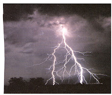
Hi Readers: Did you know that you can tell how far away a thunderstorm is from your position? Follow the lightning you see, count the seconds until you hear thunder. Then multiply your seconds times 1,128 - the speed of sound in ft/sec.
Moving on to Wind Shear. The subject, not all that well known to pilots and operators; and probably one of the most studied weather-related occurrences over the years, yet remaining highly misunderstood. In fact, the awareness factor is alarming. We have only to follow the thunderstorm and tornado reports, those originating from tropical air in the Southwest moving across the South and Midwest of the U.S., and the increased frequency of these storms in the past several years to find the source of our wind shear. Not that it doesn't occur in other areas of the world.
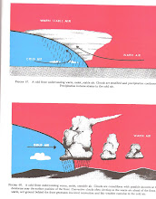
Wind shear is one of the more important weather-related occurrences, convective-type initiations; separate and distinct from known air turbulence, wake turbulence, mountain wave, jetwash, etc., that we should be aware of and include in our flight planning. Wind shear is directly related to downdrafts, microbursts, and convective vortex movements of air. The simple definition of wind shear is a sudden, drastic shift in winds speed, direction, or both in a horizontal and vertical plane. It's dangerous at any altitude, and particularly during surface operations such as approach, landing and takeoff. It can happen in airline or GA operations, VFR or IFR conditions, notably in connection with a cumulo-nimbus cloud or a thunderstorm.
Our cognizance of the hazards of wind shear must become full blown - the suddenness, the safety, and the fatal aspects are alarming; and the size and extent of the hazards are strictly after the fact.
Let's start with the accepted fact that wind shear per se is hazardous and dangerous to flight by fact and experience. And, by nature, it is associated with convective air movements such as a thunderstorm, a cumulo-nimbus cloud, rain, a snowstorm, and downdrafts producing a microburst of air which sets up the wind shear and ends in a general flattening to the surface with vortex movements at each end. The total effects to airplane control are not instantaneous and can continue and progress from one stage to another; such as an increase or decrease of windspeed, which affects the airplane airspeed, and causes pitch control problems. The wind shear, as analyzed, is actually the result of the strong downdraft of air out of the center of the storm, called the rainshaft (rain or virga). This downdraft, or microburst of air, contacting the surface, then spreads out as much as 5 miles or more, horizontally and vertically, terminated by inward and upward moving vortices ( as explained before). It is estimated that 5% of all thunderstorms produce a microburst.
Indications in the cockpit to detect the microburst and wind shear seem to be the sudden airspeed variation, and the amount, a sudden pitch change, heavy turbulence, and a tendency to yaw or roll. The extent of the occurrence is, of course, unpredictable.
Airline encounters of wind shear have been on approach to land, landing, and takeoff. The typical approach occurrence is best illustrated by a 1985 encounter by Delta Air Lines, Flt 191, an L-1011 airplane, approaching the Dallas-Ft.Worth Intl airport, flying through a thunderstorm rainshaft, in which the developing microburst forced a landing short of the runway, resulting in fire and fatalities.
In another occurrence in 1999, American Air Lines Flt 1420, in attempting a landing at night at Little Rock, Arkansas, flew into a severe thunderstorm and crosswind, losing complete control. Similar circumstances to the Delta encounter occurred.
The typical takeoff and climb situations, encountering a microburst, resulting in wind shear, have similar cockpit indications, pitch control problems, and prevention of adequate climb past the runway.
Wind Shear - PartII will follow with Analysis.
Subscribe to:
Post Comments (Atom)


No comments:
Post a Comment