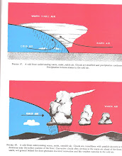
The air you fly in can be stable (no vertical movement) or unstable (vertical air movement resulting in turbulence and convective activity). Most of the time you will find the latter. You are more likely to find the stable air at night and after the sun sets. Unstable air can lead to significant turbulence, extensive vertical clouds and severe weather such as a thunderstorms and tornadoes with associated icing and hail. The sudden vertical movement of your airplane will be your warning to change course, altitude, and perhaps destination.
What causes these vertical movements? Rising air expands and cools due to the decrease in air pressure as the altitude increases. The opposite is true of descending air - as the pressure increases, the temperature of the descending air increases as it it compressed. This is called adiabatic heating or adiabatic cooling - the rate at which temperature decreases with an increase in altitude - referred to as the lapse rate. Normally this rate will be 3.5 degrees Fahrenheit (F.) per 1.000 ft.
Why does the air ascend? I guess the simplest explanation is that water vapor in the air (lighter than air) decreases the air density causing it to rise, and conversely, as the water vapor becomes less, the air becomes more dense and tends to sink. Since moist air cools at a slower rate as it rises, it it less stable than dry air. This is reflected in a dry adiabatic lapse rate (5.4 degrees F./1,000 ft). The moist adiabatic lapse rate vareies from 2.0 degrees F. to 5.0 degrees F./1,000 ft.
To sum it up, the combination of moisture and temperature determines the stability of the air and the resulting weather. Cool, dry air, then, is very stable, leading to generally clear weather. The greatest instability occurs when the air is moist and warm, such as in the Tropics in the summer. There, thunderstorms can appear on a daily basis.
But wait, there's more. There are times, quite often I might say, that an inversion of temperature occurs - the temperature of the air increasing instead of decreasing - usually a shallow layer of air at lower altitudes. The top of the layer, keeping the weather and pollutants trapped below. If the relative humidity of the air is high, clouds, fog, haze or smoke may appear, resulting in lower visibility.
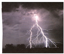
Back to thunderstorms - they can be sudden and dangerous. I became well acquainted with thunderstorms and unstable air in WWII. I remember a night flight I made in a C-47 from Dunnellon, Florida to New Orleans, Louisiana. Even at night I could see the outline of this tremendous storm near our destination, and we bounced around like a yoyo. I got in to New Orleans by sliding under the storm at 4,000 ft. It shook me up so much that I ordered oyster soup instead of oyster stew for dinner. There is a big difference - the second surprise that night. Later, in the South Pacific, I met unstable air and thunderstorms on a daily basis. And even later, over New Mexico in a T-33 at 43,000 ft, I looked up to a cumulo-nimbus cloud top of at least 60,000 ft.
You can't change how nature handles it's air, but you can study the weather relative to unstable air. Get a good weather report. And when you meet that gruesome-looking thunder cloud, say to yourself, "I can't fly through it, or under or over it, I'd better change course and altitude, or maybe my destination".
We'll take up relative humidity and the temperature/dewpoint relationship soon. Stay with me. RS.
Subscribe to:
Post Comments (Atom)


No comments:
Post a Comment